


C031-Voting District, Broward County, Florida
About
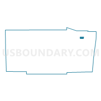
Outline

Summary
| Unique Area Identifier | 551636 |
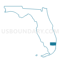
| Name | C031-Voting District |
| County | Broward County |
| State | Florida |
| Area (square miles) | 2.01 |
| Land Area (square miles) | 1.90 |
| Water Area (square miles) | 0.11 |
| % of Land Area | 94.49 |
| % of Water Area | 5.51 |
| Latitude of the Internal Point | 26.26630080 |
| Longtitude of the Internal Point | -80.16058130 |
Maps

Graphs
Select a template below for downloading or customizing gragh for C031-Voting District, Broward County, Florida


Neighbors
Neighoring Voting District (by Name) Neighboring Voting District on the Map
- A034-Voting District, Broward County, FL
- A035-Voting District, Broward County, FL
- A036-Voting District, Broward County, FL
- C006-Voting District, Broward County, FL
- C010-Voting District, Broward County, FL
- C016A-Voting District, Broward County, FL
- C023-Voting District, Broward County, FL
- C030-Voting District, Broward County, FL
- C049-Voting District, Broward County, FL
- F001-Voting District, Broward County, FL
- F005-Voting District, Broward County, FL
- F007-Voting District, Broward County, FL
Top 10 Neighboring County Subdivision (by Population) Neighboring County Subdivision on the Map
Top 10 Neighboring Place (by Population) Neighboring Place on the Map
Top 10 Neighboring Unified School District (by Population) Neighboring Unified School District on the Map
Top 10 Neighboring State Legislative District Lower Chamber (by Population) Neighboring State Legislative District Lower Chamber on the Map
- State House District 90, FL (142,553)
- State House District 95, FL (134,355)
- State House District 92, FL (133,187)
Top 10 Neighboring State Legislative District Upper Chamber (by Population) Neighboring State Legislative District Upper Chamber on the Map
- State Senate District 30, FL (458,703)
- State Senate District 32, FL (428,898)
- State Senate District 29, FL (397,144)
Top 10 Neighboring 111th Congressional District (by Population) Neighboring 111th Congressional District on the Map
- Congressional District 19, FL (736,419)
- Congressional District 22, FL (694,259)
- Congressional District 23, FL (684,107)
Top 10 Neighboring Census Tract (by Population) Neighboring Census Tract on the Map
- Census Tract 106.07, Broward County, FL (9,802)
- Census Tract 306, Broward County, FL (8,694)
- Census Tract 104.05, Broward County, FL (6,577)
- Census Tract 107.01, Broward County, FL (5,219)
- Census Tract 307.04, Broward County, FL (4,908)
- Census Tract 305, Broward County, FL (4,686)
- Census Tract 307.03, Broward County, FL (4,286)
- Census Tract 304.01, Broward County, FL (3,017)
- Census Tract 303.01, Broward County, FL (2,641)